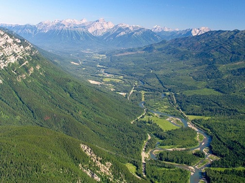
To understand the Elk River’s flood potential, look upstream. Actually, look past the stream entirely and look at the entire watershed and its history. The Elk Valley’s steep U-shape was carved out by a glacier that retreated 11,000 years ago. This glacier deposited sediment lining the ground surface in the valley bottom that restricts the downward flow of water and forces water to travel primarily as surface runoff. This means that, in instances of high water, streams and rivers will have a flashier response as less water is being held in the soil.
The Elk River is a gravel bed or a ‘free stone’ river, comprised largely of gravel, pebbles, cobbles and boulders, all greater than 2 mm in diameter, pulled by gravity from the steep tributaries and headwaters of the Elk watershed. When extreme floods occur, the bed structure is dismantled and gravels are transported downstream, changing the channel morphology. As a result, the shape and width of the Elk River is constantly changing with every flood event.
Recent and ongoing disturbances also affect streamflow. While often seen as destructive, disturbances like floods are a normal, cyclical part of ecosystems. Floods bring an influx of nutrients and sediment into the floodplain. This is similar to how forests go through a process of aging, disturbance, and renewal, essential for maintaining biodiversity and complexity.
Natural disturbances (beetle infestations and forest fires) as well as human-caused disturbances (forestry, mining and urbanization) affect streamflow and flood potential. When trees are removed, forest cover is reduced. With less snow and rainfall being intercepted, more will runoff onto the ground. Lack of shade from trees increases the rate of snowmelt, causing earlier spring melt. Greater amounts of water from a faster spring thaw, combined with the limited space for groundwater due to the glacial till, is a recipe for more intense, earlier and rapid peak streamflows.
Streamflow typically peaks between mid-May to mid-June, while the rest of the season sees steady, low flow rates. These high flows are usually harmless, but some years they turn into large floods that destroy critical infrastructure and threaten people’s homes. This begs the question: why some years and not others?
Snow pack has a lot to do with it, as peak snowmelt drives peak streamflow. It is extreme weather events that are the driving force behind flooding in the Elk Valley. Timing is everything! If a particularly heavy rainfall occurs at peak snowmelt, the large input of water can drive a significant amount of overland flow with a very fast response in the river. Rainstorms are not the only kind of extreme weather that can drive floods, however, as the third largest flood recorded June 7, 1974 did not follow a heavy rainfall, but instead saw extremely high temperatures the week preceding the flood combined with a large snowpack.
From the Elk River Flood Strategy research, one of the main concerns with flooding in the Elk Valley is that the baseflows are increasing. There is evidence to suggest that the total May-June rainfall in Fernie and Sparwood is increasing and so might the number of large storms that could instigate a flood at this time. There is also some indication that there may be greater snow in the headwaters of the Elk River by May 1 of any given year. Given that most climate scientists suggest that greater weather extremes are likely to increase in frequency, this could mean more frequent flooding in the Elk Valley.
To find out more about the human-induced effects of floods and what you can do to protect yourself, stay tuned for upcoming Elk River Current articles.