The BC River Forecast Centre has released the latest Snow Survey Bulletin, based on information collected throughout the month of January 2019 from 114 manual snow courses and 78 automated snow weather stations across the province.
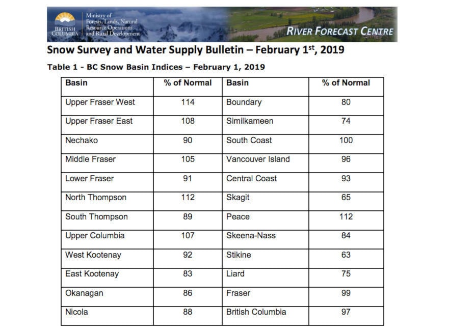
The East Kootenay snow pack dropped slightly over the month. It was at 89 per cent of normal as of January 1, 2019 and has now dropped to 83 per cent of normal as of February 1, 2019.
The West Kootenay snow pack has also dropped. It was at 103 per cent of normal in January and is now 92 per cent of normal.
The provincial average is 97 per cent — a normal snow pack. Anything from 80 to 110 per cent is considered near normal.
So far this season, snow accumulation has been dominated by persistent weather patterns, the report says. Most of this year’s snowpack built up rapidly over a 5-6 week period from early-December to early-January. Weather into February has shifted again into the dominance of Arctic air across the province, with extremely cold temperatures and limited snow accumulation. This pattern is expected to continue at least into the middle of February.
By early February, nearly two-thirds of the annual BC snowpack has typically accumulated. Seasonal snowpacks can still change significantly with two or more months of possible snow accumulation left.
As for what to expect for the rest of the winter, the Forecast Centre says there is a high likelihood of El Niño developing through the rest of this winter and continuing into the spring.
“Temperature anomalies in the equatorial Pacific Ocean have been easing since December. Typically, El Niño is linked to warmer winters across British Columbia, with a trend towards lower than normal snowpacks. However, the impact of El Niño on winter snowpacks in BC is highly variable and does not always mean lower snowpacks - for example, 2007 had significant snowpack across the province, despite being an El Niño winter. Additionally, warm sea surface temperature anomalies persist in the Pacific Ocean off the BC/Alaska coast, though they have generally weakened since mid-November. Warm temperature anomalies in the Pacific often have a similar or enhancing effect when they occur in phase with El Niño, as was the case in 2014- 15 and 2015-16. Seasonal weather forecasts from Environment and Climate Change Canada have shifted over the past month, with a transition to an increased likelihood of below normal temperatures forecasted over February to April.