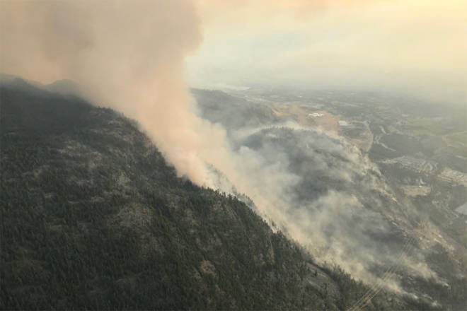
BC Wildfire said the Eagle Bluff wildfire, north of Oliver is currently estimated at 280 hectares in size.
Air support, helicopters, are already working the site today and will have some assistance from air tankers.
BC Wildfire information officer Taylor MacDonald said crews did face some winds throughout the day on Monday, but the main challenge is the steep, rock terrain.
Although BC Wildfire is calling it an interface fire, MacDonald said that there hasn’t been any damage to structures. Trailers filled with structure fire suppression equipment have been deployed to the area.
Tweet-video
********************
An evacuation alert is still in place for 206 properties north of Oliver as BC Wildfire continues to fight a 225 hectare fire at Eagle Bluff in the Gallagher Lake region.
The properties, on 42 parcels, include residential homes, RV parks, mobile home parks and recreational campsites. The Regional District of Okanagan-Similkameen has been working with BC Wildfire, Osoyoos Indian Band, RCMP, Oliver/Osoyoos Search and Rescue and Penticton SAR to ensure residents under evacuation alert have been notified.
READ MORE: Evacuation alert issued for properties near Gallagher Lake wildfire
Wasting no time - 3 of the 4 water bombers filling up at Vaseux Lake this afternoon - what are these planes called? #eagleblufffire #firefighting #bcwildfires #GallagherLake pic.twitter.com/GwaJqB0mMU
— Paula Bransco (@motormama7) August 6, 2019
The cause of the fire, which was discovered on Sunday night, has not yet been determined. While 100 personnel arrived on Monday, along with two water tenders and air support (eight helicopters and air tankers), 20 BC Wildfire workers worked on the site overnight.
It is now considered an interface fire, which occurs when wildfires cross from forested areas into the community — with the potential to affect structures.
Air tankers ran a line of retardant along the east flank to limit the potential of overnight growth as resources were challenged by the steep and rocky terrain. Structure protection units and a specialist were on scene.
READ MORE: Raptors evacuated due to threatening South Okanagan wildfire
UPDATE: The Eagle Bluff fire is ~225 ha. Airtankers on site this evening dropped retardant along the east flank to limit the potential for overnight growth. 20 personnel will continue to work through the night. More information here: https://t.co/lcp78UXToS #BCWildfire pic.twitter.com/tERDQh6uop
— BC Wildfire Service (@BCGovFireInfo) August 6, 2019
The situation is actively being assessed and should conditions deteriorate, evacuation orders may be issued for affected residents. The RDOS suggests those under evacuation alert should designate a meeting place for family outside of the evacuation area should they become separated, gather essential items (including medications, valuable papers, keepsakes etc.) for quick departure, prepare to move any disabled persons and/or children, moving pets and livestock to a safe area, arranging accommodations, monitor news sources for information.
READ MORE: Smoky skies bulletin for South Okanagan due to wildfires
The emergency operations centre can assist with residents needing transportation for an evacuation area by calling 250-490-4225. In the event of an evacuation, reception centres will be opened if required.
The parcels under evacuation alert are:
Brauns Road - 100, 129, 146,162
Sundial Road - 102
Gallagher Lake Road - 157, 165, 171, 174, 184, 189, 195, 196, 198
Enterprise Way - 176
James Way - 205, 215, 279
Manuels Canyon Road - 234, 241, 248, 251
Highway 97 - 3261, 3275, 3525, 3550, 8331, 8583, 8703, 8713, 8799, 8961, 8965, 8967, 8977, 8982, 8984, 9001, 9017, 9057 and 8465
McIntyre Creek Road - 410
To report a typo, email: editor@pentictonwesternnews.com.
<>@PentictonNews
newstips@pentictonwesternnews.com
Like us on Facebook and follow us on Twitter.