UPDATE - 9:30 a.m. Thursday, August 16
There is no relief from the hot, dry conditions in sight, according to the Regional District of East Kootenay, which has issued an update on weather conditions and wildfires burning around the region.
“The forecast is calling for continued hot, dry conditions with no significant rainfall in the near future. There is a chance of isolated thunderstorm activity over the next day or two, but in general, it will remain hot and dry,” said the RDEK in a Facebook post on Wednesday night.
The smoky conditions are also expected to continue to persist.
The RDEK said while this can keep temperatures down and help on the fire front, the smoke could be difficult for residents, particularly those with breathing difficulties.
For general information about wildfire smoke and your health, contact HealthLink BC at 8-1-1 (toll free, 24 hours a day, 7 days a week).
“It is recommended that if you have breathing difficulties you try to spend some time inside to get a break from the smoke. Using an air conditioner that cools and filters air may help,” said the RDEK.
For more information on current air quality, visit BC Air Quality.
RDEK Elk Valley fires update (as of Wednesday night)
Leach Creek (N12565)
Located in the Corbin area, this fire is being held (which means it is unlikely to spread). There were 9 firefighters on site in addition to equipment and the fire is now 95% guarded – which means they have completed a 4 metre wide fire guard of exposed mineral soil around almost the entire perimeter. The evacuation alert in the Corbin area was rescinded Wednesday morning.
Mt. Erickson (N12574)
This lightning caused fire is NE of Sparwood and is highly visible from Highway 3. They have been actioning it and it is currently estimated at 1.5 hectares.
Coal Creek FSR (N12395)
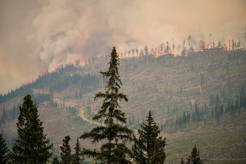
Crews are making progress on the Coal Creek Fire and are currently working on building containment lines on the south side. They have put a rough perimeter map up on the BC Wildfire website today, so if you zoom in on the map you can see the general area of the fire. They are still estimating the fire to be approximately 713 hectares; however, as we have noted the smoke across the entire region has challenged efforts to complete accurate mapping. This fire is not currently threatening communities. They had 6 firefighters, 1 helicopter and 5 pieces of heavy equipment on site today.
Sage Creek (N12024)
Crews are continuing to make progress on this fire and are gaining some ground. They had 102 firefighters, 12 helicopters, 3 pieces of heavy equipment, 2 airtankers on the fire today, which remains on the BC side of the BC/AB border. The fire remains estimated at 1936 hectares.
Morrissey area fires
We have also been getting some calls on a couple of small fires in the Elk Valley in the Morrissey / Lodgepole Creek area. We are hoping to have some additional information from the BC Wildfire Service in tomorrow’s update on these fires as we know at least one of them has been visible to residents.
—
On Thursday, The Free Press reported:
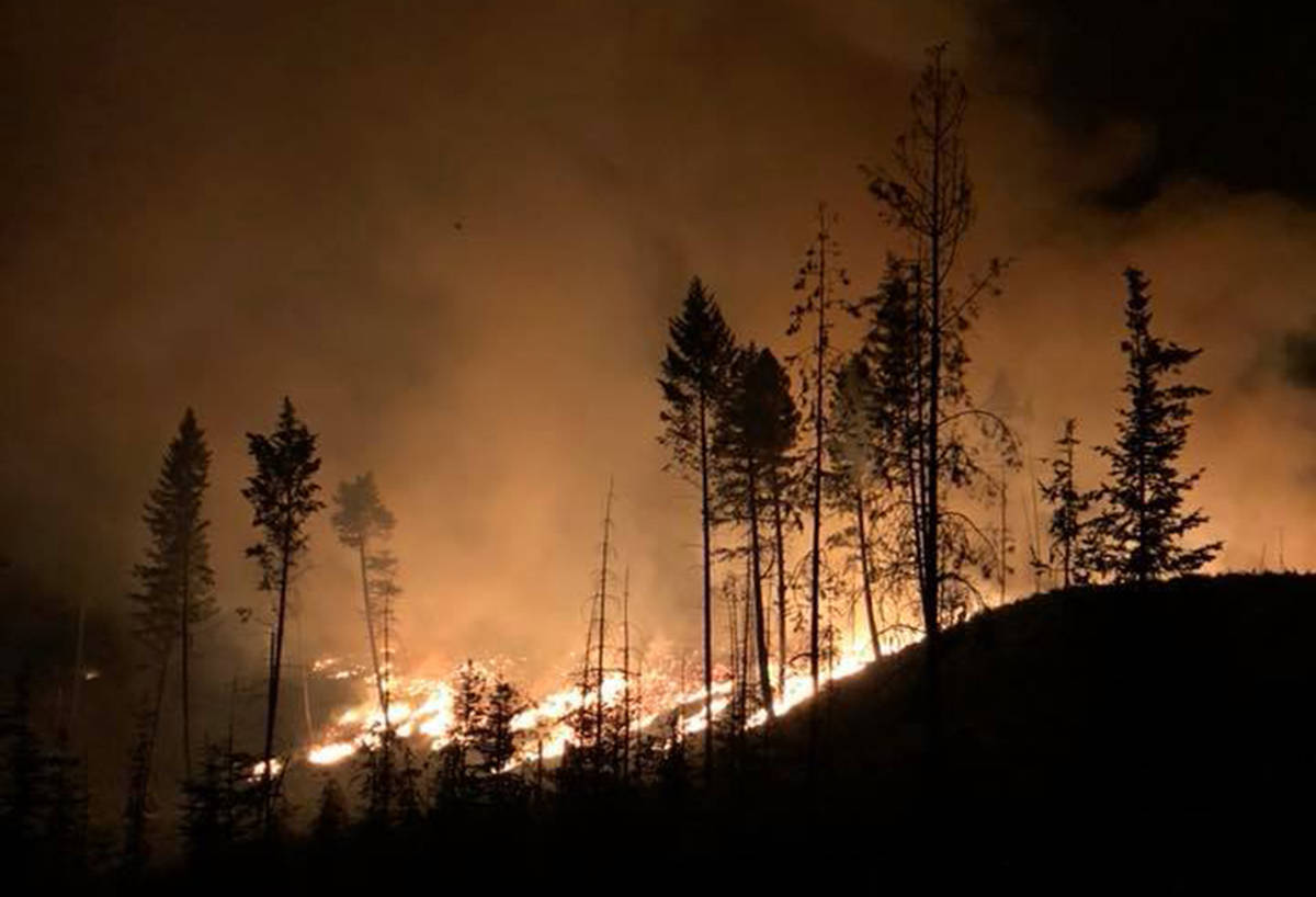
The Elk Valley is shrouded in smoke as multiple fires burn across the region, prompting road and facility closures, and evacuations of some areas.
On August 10, a wildfire was discovered down Coal Creek Road, approximately 15 kilometres from the township of Fernie.
By the end of the day, it had grown to 150 hectares, with logging crews in the area working to secure their equipment at the base of the mountain where the fire was burning. Shortly afterwards, Rocky Mountain Forest District established a road closure for public safety.
For the first two days, little support was available from BC Wildfire Service as other fires flared up across the Southeast Fire District, some prompting the swift evacuation of homes.
As the Coal Creek Forest Service Road (FSR) fire was not considered a threat to communities or property, crews focused their efforts elsewhere. By Saturday morning, the out-of-control wildfire was reported as 512ha in size and within hours had spread to an area crews estimated at 650ha.
According to the incident commander on scene at the time, BC Wildfire Service was doing what it could with limited resources and multiple wildfires burning in the region. One helicopter and some heavy equipment was on scene to assist with the fire.
By Sunday morning, the Coal Creek FSR fire was 713ha and displaying “vigorous fire behaviour”, according to BC Wildfire Service, which upgraded it to a Wildfire of Note.
This was concerning for Fernie mayor Mary Giuliano, who was holidaying in the Okanagan over the weekend.
She continued to receive updates from BC Wildfire Service and said she had full confidence in the agency to manage the fire.
It was initially reported as human caused, however, the latest advice from BC Wildfire Service shows the fire is still under investigation. Last week, MLA for Kootenay East Tom Shypitka joined calls for a backcountry closure due to the increasing wildfire risk.
Giuliano also believes it’s time to restrict access to the backcountry.
“I think there should be a ban on all areas of the forest because if this one (the Coal Creek FSR fire) is human caused, that’s a really good reason there should be a ban everywhere,” she told The Free Press Sunday.
“I know there are people who say it will affect their business but honestly if the forest is gone, what business will there be for anyone?”
That night, Fernie’s rifle and archery ranges were shut down in co-ordination with the closure of Coal Creek Road and surrounding service roads.
The Fernie Rod and Gun Club (FRGC) announced on social media that anyone caught using the ranges during the closure would lose their membership and be reported to authorities.
The FRGC 3-D Archery Summer Shoot and Elk Valley Extreme have been cancelled and will be rescheduled.
On Monday night, authorities reassured Fernie residents that their safety was not at risk from the Coal Creek FSR fire. The wildfire was holding at 713ha and being worked on by 14 firefighters, a bucketing helicopter and five pieces of heavy equipment.
The heavy equipment had completed 95 per cent of a machine guarded barrier around the perimeter of the fire.
The fire centre clarified that this did not mean the fire was 95 per cent contained, but this method generally does help in slowing down the fire.
A machine guard is achieved by scraping down a four-metre wide line around the perimeter of the fire, in order to remove fuels and discourage the fire from travelling.
As of press time, Coal Creek Road remained closed at the 33km mark, which is located at the River Road-Ridgemont Road intersection. Anyone who proceeds past this point faces a $173 fine under section 22.2 of the Forest and Range Practices Act.
BC Wildfire Service asked that all curious onlookers obey road closures and stay away from the area while the heavy machinery is in use. Signage and barricades were in the process of being posted on closed service roads late Monday.
Corbin evacuation
On Sunday night, an evacuation order was issued for 10 properties threatened by the Leach Creek wildfire in the Corbin area, 21km southeast of Sparwood.
The fire was sparked by lightning and, as of press time, was 30ha in size. Four firefighters remained at the scene of the fire, which was 95 per cent machine guarded with a four-metre wide fire guard of exposed mineral soil created around the perimeter.
On Monday, Teck Coal confirmed operations had been temporarily suspended at its Coal Mountain mine and employees sent home.
The mining company said all staff had been reported safe and there was no risk to the operation itself.
On Tuesday, the Regional District of East Kootenay downgraded the evacuation order to an alert.
“It is important for people within the alert area to remain prepared and follow updates on the Leach Creek Fire,” read a press release issued by the RDEK.
“In addition, anyone wishing to remove recreational vehicles from the area is encouraged to remove them now in the event that conditions worsen and an order needs to be re-issued.”
A map of the alert area is available at Rdek.bc.ca and includes the portion of Corbin Road in Electoral Area A and the community of Corbin.
The District of Sparwood has issued an evacuation alert in connection with the same fire. It covers the Coal Mountain mine property and a small portion to the northeast.
An information line has also been set up. Call 250-426-2188 or toll free 1-855-346-2188 to get the most up-to-date information on the Leach Creek wildfire.
Check Thefreepress.ca for any updates in relation to the current wildfire situation, and remember to have a 72-hour preparedness kit ready in case of an emergency.